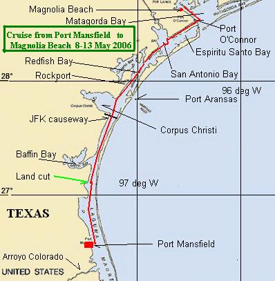
Raid, (group small boat trip) from Port Mansfield
and Rockport
to Magnolia Beach,Texas in Matagorda Bay
May 8 through 12, 2006. final destination was the
Duckworks 4th Annual
Messabout.
The route
The Participants

Wayne, Luis, Gerry, David, Noel
meeting at
Rockport, Texas, Cove Harbor, Off the
Hook restaurant, the evening of Tuesday, May 9, 2006,
before
commencing the Raid part of the trip the next day.
~~~~~~~~~~
Gerry Mittelstaedt and David Hetrick Sr. left Port Mansfield late
Monday afternoon, about 6:20 PM and sailed north in lower Laguna
Madre, in the ICW (Intercoastal Waterway.) This is the part of Laguna Madre where the wind
gets the greatest fetch over the bay. Wave height was up to around 2
ft. and the boat made good speed sliding down the fronts of the
waves. Darkness fell before they reached the land cut and they
had to rely on lighted markers to stay in the ICW. These markers are
quite a distance apart, and just after passing one, with eye level
just a few feet above sea level, the next lighted marker was not
easily seen. Often a compass course was determined from what had been
steered so far (real practical direction) and since the channel is
straight here it sufficed to keep course until the next marker was
seen. As wind and wave were following, but not exactly astern
steering was a challenge as each wave attempted to cause a broach.
They continued through the land cut where conditions were
very mild. There was almost no wave action, and the wind held almost
astern, making for a fine run. When the wind has been blowing for any
appreciable time from the S. or SE. the water in the Laguna Madre
builds up at the southern end of the land cut, making a significant
north-going current. This assisted our fast passage by 1 to 2 mph.
The land cut seems to be deeper on the East side. The moon was just 2
days before full, and for most of the night we had plenty of light to
navigate. The moonlight shown off the sandy strip nearest the water
on the eastern bank. If we headed north some 40 to 50 ft. off the
moonlit bank we always had sufficient water to sail. During a few
moments of inattention we found that there are very shallow areas on
the west side of the channel. A bit of shoving with an oar got us
back in the channel on these few occasions. Sailing like this is
quiet. The sounds of crickets, birds, and porpoise coming quite close
to the boat made for an enchanting and peaceful sail. There are
several fishing camps (small houses) built at the edge of the land
cut. Some were occupied and with noisy generators were throwing
lots of light out to attract bait fish, and
the big ones who follow those bait fish. Seagulls, skimmers and other
birds were in abundance in each of these teeming pools of light. The
fishermen, when awake, always gave us a wave as we sailed past, and
we gave them a wide berth so as not to foul their lines.
We sailed on past the entrance to Baffin Bay (Texas) which is
roughly northeast of King Ranch. The moon went down about 4 AM and
for a couple of hours navigation was more difficult. We could easily
see the lighted markers, but the unlit can and nun
buoys were a menace. Often we only saw them when they were
immediately abeam. We managed to have a glancing blow with one green
can, with no damage. They are made of plastic now, foam filled, and
left no mark on the boat. A noisy jet turbine helicopter was
patrolling up and down paralleling the ICW, but not over the ICW. It
had a very strong set of lights shining straight down, and looked
like a pillar of light with their red nav lights on the machine
itself. Where they were looking the water was very shallow, if there
was any water at all.
We continued the length of northern Laguna Madre, noting many larger and well appointed fishing camps on the way. Some of these houses were more than one story, and some were larger than our homes in McAllen. Many had planted trees, which was a surprise to us, as there are no trees of any size on the spoil bank islands in southern Laguna Madre. In some cases there were a few palm
trees, in others there was a veritable forest of what I can only guess are salt cedar or Tamarisk. The route continued under the JFK Causeway and across Corpus Christi Bay which
was in its usual choppy condition, and with an almost following wind and wave heights up to perhaps 3 to 4 ft steering was a challenge.
Markers in Corpus Christi Bay are quite far apart, and we were glad to cross in daylight. The ICW crosses the Corpus Christi ship channel between 2 spoil bank islands (these paralleling the ship channel).
The primary bouyage here is for the ship channel, and consulting the chart is a good thing, as there is a little jog in the ICW, or so it seemed as activity around the drilling rig manufacturing facility at Port Ingleside has a few barge mooring buoys out which seem to be in the ICW. The cranes and construction activities at this facility are huge, can be seen for miles, and are a good landmark.

(See cranes in the background in above picture)
Commercial traffic is heavy in this part of the ICW. There were many barges with specialized equipment which were being moved about.
There is some sort of shipyard working on a military vessel, and many cuts into the mainland supporting sport fishing, as well as commercial fishing (almost exclusively shrimping.) Then there are a few high dollar developments such as -City-by-the-Sea- where real money meets the shore. The spoil bank islands across from this development are very natural. They are a haven for all sorts of shore birds. One of the most spectacular and colorful rosette spoonbills I have ever seen was feeding just across the channel from one of the industrial sites.
There is a high bridge over the ICW where State Hwy 361 crosses from Aransas Pass (on the mainland) to Port Aransas (which is on N. Padre Island.) It looks like one might be heading ashore by going under the bridge but actually this is the route of the ICW. There is a channel from Aransas Pass to the actual pass out to the open Gulf of Mexico on the north side of
this causeway. If one cuts west at this jucture one will enter the Aransas Pass harbor.
We continued on to Cove Harbor, which is some 4 miles south of the center of Rockport, tacked into the harbor and tied up to the dock near the smaller public launching ramp at the SW corner of Cove Harbor. This harbor has an interesting mix of commercial, yachting and sport fishing activity. The restaurant is very good.
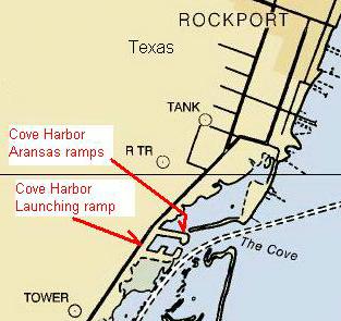

Ocean
Breeze Gerrys boat at rest at the SW corner of Cove Harbor.
Note the almost complete sun-shaded open cockpit area.

At Cove Harbor Gerry and
David met up with the other participants, had a good meal at Off
the Hook,
(which is adjacent to the Aransas Nav. Dist.
launching ramps on the North side of Cove Harbor)

and slept in spare bunks on Noels and Luis boats before heading out the next day.
Wayne had some motor trouble and decided not to sail with the group, but to trailer his boat to the Messabout site and see us there on Saturday.
On Wednesday morning our little flotilla sailed north across Redfish Bay, passed Blackjack Peninsula the wildlife refuge where the Whooping Cranes winter. There were abundant porpoise
keeping us company as the bay narrowed into the land cut channel near the tip of Blackjack Peninsula. A sandwich lunch was served up while under way, and we continued on into San Antonio Bay.
Winds were favorable (from the SE) and moderate. We made great progress.
Luis in his Precision 165 was the fastest and nimblest boat in the group.
Gerry and David in their homebuilt 13 ft. skiff was the slowest.
Noel sailing in his Cortez 16 was making very comfortable progress.
Luis and Noel wandered about to slow their progress to keep the fleet together.

Luis Cisneros
 -
-

Noel Nicholls in his Cortez 16 - - - - - Luis Cisneros in his
Precision 165
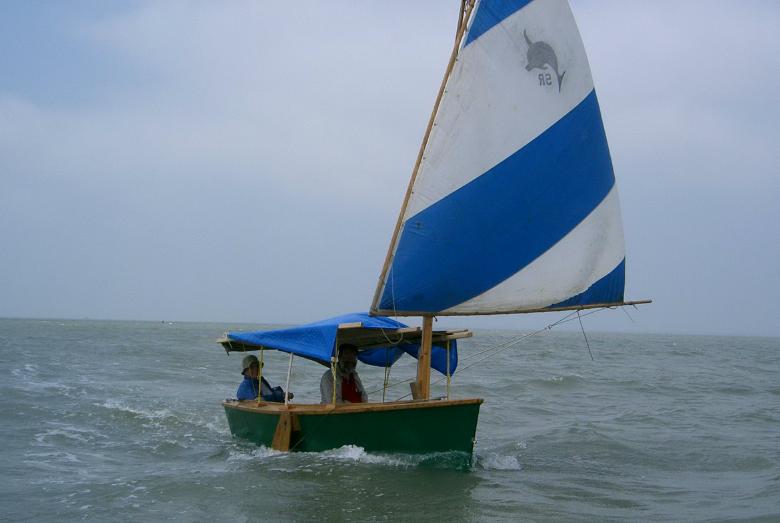
Ocean Breeze the 13 ft. boat, with David and Gerry
We sailed out from the protection of the land cut into open San Antonio Bay. The first big barge tow was encountered, and we began to learn how to best avoid this commercial traffic.

The weather forecast had said that a frontal passage (norther) was coming, and was expected to arrive about midnight. Our plan was to find a comfortable place to hole-up in the next land cut area and wait out the inclement weather, and wind shift, as northerly winds were only expected to last 6 to 8 hours. There was mention of thundershowers ahead of the front with small craft warnings. We saw some dark clouds and a significant amount of lightning in the NW and later in the day heard more dire warnings than were broadcast earlier. The wind abruptly shifted to out of the NW and we turned about and fled for shelter in the more enclosed part of the ICW land cut which we had recently left.

Noel and Luis made it into the land cut before a sudden gust of over 45 mph hit. Gerry was a few hundred yards short, and was caught in more open water. All of us ran for our lives. Noel dropped 2 anchors and fetched up safe. Gerry totally loosened his sheet, and the unstayed mast allowed the sail to totally weather vane. Soon after he dropped sail, and he and David scudded before the wind. The rain was blinding, one could only see 20 feet. It beat down the waves. In some 20 minutes it was all over. The wind even re-established out of the SW at a very mild breeze. It was all very disorienting, as suddenly Gerry found himself in a place where there were no visible markers. Later as dusk fell the lighted markers showed themselves, and he discovered that he was out of the channel on the wrong (bay) side of the spoil bank island.
After some tacking about Gerry found a beach of broken shell where he and David pulled the boat up, put the anchor out, lit a lantern, and hunkered down waiting for the frontal passage (norther.) It hit almost on time, and the wind switched out of the north and blew quite briskly, perhaps 25 to 30 mph. It was moderately cold, perhaps in the mid 50 deg range. After an
uncomfortable night it dawned clear with a brisk wind out of the north. By 9 AM Noel and Luis discovered Gerry and David and the fleet re-gathered at anchor, each glad to see the others alive and safe.
He bent my mast...
Well, actually we all bent Noel's mast, but we bent it back again.
During the storm Noel had lost a main halyard up the mast. The next morning as he and Luis were sailing south and found Gerry and David in our skiff Ocean Breeze nestled up on the beach on the wrong side (East side) of the spoil bank island. Noel lost his backup halyard while maneuvering to stop and anchor nearby. Noel drifted across the ICW and when he reached the shallows on the other (SE) side he went overboard with a line and towed his boat back to where Luis had anchored. Gerry and David hummed the song of the Volga boatmen, as Noel was doing such a good job towing his boat against the fresh wind. Luis had anchored slightly off the island, and just out of the channel where it was about 2.5 ft deep. Noel tied off to Luis (see picture)

then firmly set 2 anchors before casting off from Luis and trusting his own anchors.
We all met on the spoil bank island and had a good chat. The wind was out of the North, about 20 to 25 mph.
We discussed methods of re-reeving halyards in Noel's mast. Lowering the mast with the boat floating and anchored was considered difficult. Hoving it over was considered, and possible because a topping lift which was attached to the top of the mast was available to pull. Gerry and David had hove down boats before and thought it a viable method. So, we positioned the boat and began pulling it over. The top of the mast began to bend, then the mast took a reverse -S- bend below the place where the shrouds are attached.

Then, rather suddenly, the lower bend actually the bent the metal. Horrors. We relaxed the tension, the boat went upright and the mast had an approximately 15 degree bend about one third up from the deck. We all had sick feelings in the pits of our stomachs... at least I did, and I am sure Noel did.
So we did the other thing, we lowered the mast. With 4 of us, it was not that difficult. We anchored and held the boat with anchor lines and long lines bow toward the island and lowered the bent mast. It was not as difficult as anticipated. Once the mast was down we brought it ashore. Then we got creative. The brick-like mat was set down perfectly straight and almost flat. We decided to have a go at straightening the mast. At first 2 guys stood on the bottom end. A piece of 2x lumber found on the beach was set under where the bend was and we forced the upper part of the mast down. After several tries we found that it had straightened some. We realized that to completely straighten it we would have to over bend it, and also prevent the dreaded -S- curve from forming in the lower part. As it turned out, the stainless cables holding the brick mat together were at a convenient interval for tying the end of the mast, and the area of the bend. We found more 2x stock and split up some other boards found on the beach and jammed them into the open holes in the bricks fully immobilizing the lower part of the mast so that we could set the mast laterally and do the necessary over bend laterally. We bent, then relaxed, examined the progress, then bent again. After some half dozen cycles the mast was straight, much to our surprise and delight we fixed the problem. The picture below shows what things looked like after success. We did not take -before- pictures.... did not have the guts to do so.

The mast laid out, now straight.

The brace at the bottom of the mast.

The brace at the bend site.
We reversed the mast lowering process after reeving the halyards and Noel was back in business, much relieved I am sure.

The rest of the day was spent resting and getting gear in order to continue the trip when the wind backed to its normal SE flow.
When sailing the ICW past Espiritu Santo Bay the whole route is protected by the mainland on one side and a constant strip of spoil bank islands on the other side of the channel. The only places where there are passages to the Bay are at the beginning, where one can cut into the bay instead of going into the ICW - about mid way along at a small fishing village, at ICW mile 485, between markers 6A and 6B. The chart reports a 2 ft. depth - and at ICW mile 488 at marker 1 (a green lighted marker) where a channel defined by lighted markers cuts completely across Espiritu Santo Bay to Matagorda Island and the facilities of the wildlife refuge on the island.

In the southwestern half of this passage the vegetation on the spoil bank island is thick and lush. It supports a wide variety of wildlife, and more different bird songs are heard than in any area during this whole mini-voyage. Redwing blackbirds, meadowlarks, and even mourning doves were in abundance. From the fishing village on to Port OConnor it was a different story. The
vegetation was more sparse, and the vegetation on the mainland side was very sparse and stunted.
For this trip we stayed in the ICW often jogging to the side of
the channel to avoid the heavy barge traffic. The towboat captains
are very polite, but there are limits to their maneuverability and it
is best to stay out of their way. They all monitor channel 16, and
when clarification is needed they will tell you which side is best to
pass. On one occasion Gerry nosed into the bank on the windward side,
as did another barge tow when the two captains negotiated passing.
The one who nosed into the bank was double wide. This maneuver was
truly amazing to watch... and listen to on Ch 16.
Port OConnor has grown and changed a great deal
in the last 20 years. It used to have a more commercial feel. Now
there are dozens of huge waterfront homes and considerable sport
fishing activity. The Coast Guard has a buoy tending facility here.

Port OConnor has jetties poking out into Matagorda Bay. Unlike
most of the Texas jetties there is seriously shallow water inside the
jetties and outside the marked channel (ICW). When boating here make
a serious effort to stay in the channel between the jetties.
As Gerry headed out the night before Noel and Luis, he was well
ahead of them. As Noel and Luis passed the fishing village, and Gerry
was some miles ahead, there was some gossipy chat on
channel 16 about 2 little sailboats sailing in company. This
was good news, and Gerry expected that the other 2 boats would catch
up before the end of the day. In fact they did catch up just between
the Port OConnor jetties as we all entered Matagorda Bay and -turned
the corner- on to the Northwest for the final leg of the journey to
Magnolia Beach.
The whole fleet had a -gam- (chat between moving boats), then the faster boats pulled ahead. We all arrived after sunset as a beautiful full moon rose in the east. Each of us had
difficulty locating the Magnolia Beach park in the dark. In fact Gerry stopped and spent the night in the Indianola Beach Park after some wandering back and forth along the coast, and set sail on Saturday morning to arrive at the proper Messabout site by 9 AM.
The PD Racer -World cup races- were held later in the day. It was great fun seeing those robust 8 ft. boats sail around a race course in moderately high winds.
The Duckworks Messabout attracted a number of fine looking boats.
A good time was had by all.
One hazard of this beach is that the ship channel from the open Gulf of Mexico to refining facilities in Port Lavaca and Palacios is only about a mile off the beach. When a large tanker comes through it throws up enough wake to create a mini-tsunami. Those with tender boats do well to hold them off so that they do not pound on the beach.
Calendar
Monday, 8 May 2006
Leaving Port Mansfield in the afternoon.
Sail North all night through the land cut.
Tuesday, 9 May 2006
Sailing across Corpus Christi Bay and arrive in Rockport early afternoon.
Wednesday, 10 May 2006
Leaving Rockport sailing North in company with Noel and Luis.
Caught in frontal passage storm in San Antonio Bay.
End up half hauled out and anchored on spoil bank island.
Thursday, 11 May 2006
Re-grouping with Noel and Luis.
Resting, working on Mast.
Leaving at dark, sailing across San Antonio Bay in near calm.
Friday, 12 May 2006
Sailing to Port OConnor, then heading West halfway down Matagorda Bay
Stopping late at night at a waterfront park in Indianola.
Camping on the beach until morning.
Saturday, 13 May 2006
Broke camp and early morning sail a fraction of a mile
to Magnolia Beach, the site of the Duckworks Messabout.
Navigation tools used on this mini-voyage
Statistics:
Total statute miles Port Mansfield to Magnolia Beach = 161.5 miles
Total time from launch at Port Mansfield to arrival at Magnolia Beach = 101 hours
Total actual sailing time from launch at Port Mansfield to arrival at Magnolia Beach = 57.5 hours
Average speed during actual running time = 2.81 statute miles per hour
(Average speed and distance traveled does not take into account the 6 hours of tacking in the channel after leaving San Antonio Bay. These maneuvers slowed forward progress to the goal, and cause a negative reflection on boat speed, which was quite another matter. The current through the first land cut is also just grossly figured in to the time/distance calculations, as is the almost total becalming Thursday night/Friday early morning. The figures above are for total voyage, and are only reflective of performance over the long sail, not in any particular setting.)
For the first part of the voyage, from Port Mansfield to Rockport, total time was 25 hours.
Distance covered was 96.5 miles.
Speed for this leg of the journey (for the 13 ft. 1 inch Ocean Breeze) was 3.86 mph.
updated 2 June 2006
2007 Duckworks Messabout - Magnolia Beach, TX - near Victoria, TX
2008 Duckworks Messabout - Magnolia Beach, TX - near Victoria, TX
and The end of the first Texas 200 cruise
2009 Duckworks Messabout - Magnolia Beach, TX - near Victoria, TX
and The end of the 2009 Texas 200 cruise
the 2009 Texas 200 by Andrew Linn - PD Racer fleet with others
2010 Duckworks Messabout - Magnolia Beach, TX - near Victoria, TX
and The end of the 2009 Texas 200 cruise
Texas 200 in 2010 map etc.
the 2010 Texas 200 by Andrew Linn - and the pink Laguna - Laguna Sink-o
Texas 200 in 2011 Port Isabel, TX - to - Seadrift, TX
Duckworks report on Texas 200 in 2011
Texas 200 in 2012 Port Isabel, TX - to - Seadrift, TX
The 2006 Duckworks Messabout page on
this site.
The 2005 Duckworks Messabout page on
this site.
The 2004 Duckworks Messabout page on
this site.
A 2003 Duckworks Messabout page on this
site.
to Duckworks Magazine
page
home page for this site.
Mini Voyages index page.